
Thunderstorm 101: Danger signs
In a follow-up to part one, Ross McLean of Helensburgh warns of the dangers nature can unleash through thunderstorms

Part Two: The dangers associated with thunderstorms are lightning, strong winds and microbursts, hail and heavy rain, tornados and waterspouts, roll clouds and squalls.
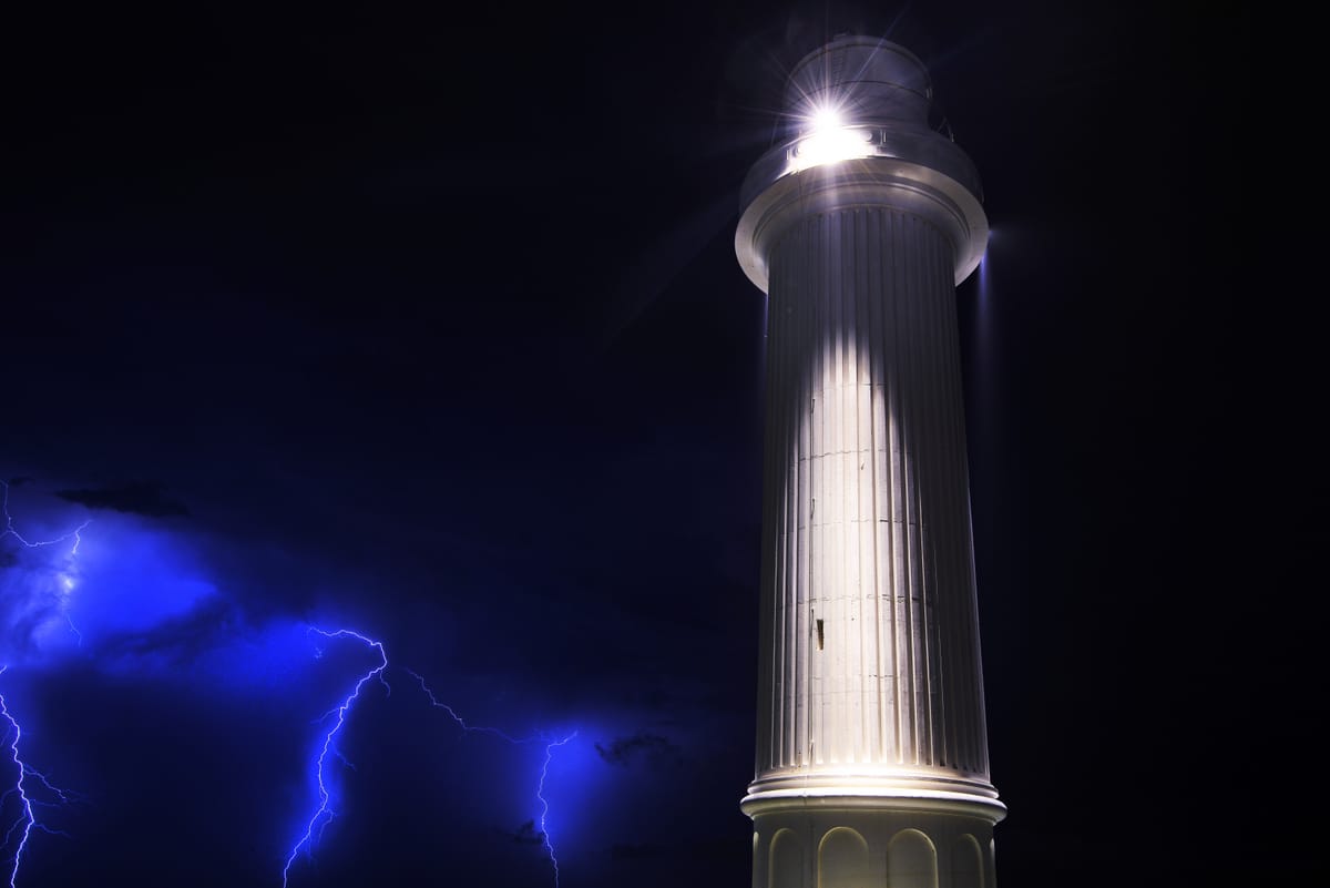
Lightning
Lightning can strike the ground near you from as far away as 20 nautical miles, (37.4 kilometres), even though you cannot see the thunderstorm clearly – perhaps just the top of the anvil. At a PGA tournament in the US, seven spectators were struck by lightning and the top of the thunderstorm’s anvil was only just visible beyond some mountains in the far distance. Since then, US PGA postpones or cancels all golf tournaments if there is even a sniff of a thunderstorm about.
Here's a good rule:
If you can hear it, fear it, but if you can see it, flee it ...
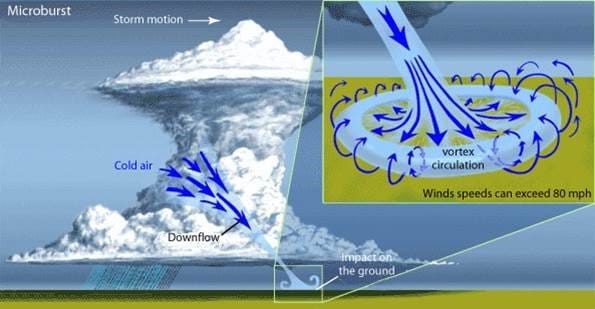
Strong winds and microbursts
For mariners, thunderstorms have always been associated with strong winds, especially at the rear of a thunderstorm, but it is only in the past 40-50 years that the airline industry has taken microbursts seriously. A microburst is a localised column of sinking air (downdraft) within the thunderstorm and usually less than or equal to 2.5 miles in diameter. Microbursts can cause extensive damage at the surface and can be invisible. As a thunderstorm develops, water droplets/hailstones are suspended within the updraft. Sometimes an updraft is so strong, it suspends large amounts of these droplets and hailstones in the upper portions of the thunderstorm. There are many factors that can lead to evaporative cooling (sinking air) and therefore weakening of the updraft. Once this occurs, the updraft is no longer capable of holding the large core of rain/hail up in the thunderstorm. As a result, the core plummets to the ground. As it hits the ground, it spreads out in all directions. The location in which the microburst first hits the ground experiences the highest wind speeds and greatest damage. (Gusts can be more than 160km/h.
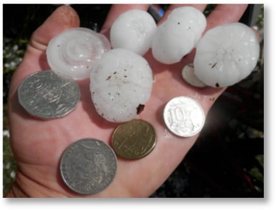
Hail and heavy rain
Thunderstorms create varying amounts of hail and rain. Some of the most severe hail and rain occurs when a single thunderstorm forms a cluster and continues to affect a given location for an extended period of time. An example of this is the 2010 Brisbane floods. Three-quarters of the council areas within the Brisbane area were declared disaster zones.
Rainfall from the same storm devastated communities in the Lockyer Valley.
Meanwhile, in Sydney, hail blocked the gutters and downpipes of a large factory complex, causing rainwater to build up on the roof; the result was catastrophic for the building. Engineers can’t design for that.
Tornados and waterspouts
All thunderstorms rotate, supercells more than others. As a thunderstorm rotates, it can develop a spiralling column of air that reaches the ground or surface of the ocean. The more dynamic the thunderstorm, the more dynamic are the tornados/waterspouts. It is not uncommon for a thunderstorm to spawn several such spirals as was evident at Lennox Head, NSW, in 2010 and off the coast of Florida.
Tornados/waterspouts in the southern hemisphere will travel around the rear to front of a cell as the thunderstorm moves over the surface of the earth. Once the tornado/waterspout reaches the front of the thunderstorm, it loses its energy as it is virtually run over by the cell. The rotation is again governed by Coriolis, with air entering the cell, and turning to the left.
Roll clouds and squall lines can also follow this path, appearing to come from the right and swinging to the left but never in the opposite direction.
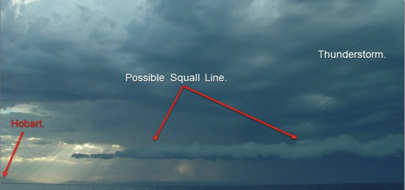
The photo above of the possible squall line was just that. Taken from STV Windeward Bound as we approached Hobart, this chappy could have been a disaster. However, after all plain sail was reduced, it rolled harmlessly overhead, Forty-five minutes later, we were in something in the order of 50 knots on the nose with gusts, reducing Windeward Bound’s speed to about 1 knot over the bottom. With Hobart in sight, it took us until 11pm to reach our anchorage. Always assume the worst, as it is better to look a little silly for being cautious than really stupid for not.
And remember – nobody goes to sea when there is a cyclone warning unless to escape a very poor anchorage. However, we are often at sea or enjoying the great outdoors when a thunderstorm comes trundling along.
In the next part we will look at the different types of thunderstorms. How many can you name?
Read part 1: The Science of Storms Explained
Part 3 will be out in July
About the writer
Ross McLean has spent more than 40 years observing and recording thunderstorms around the world, from Australia to South Africa and the US. He spent one and a half years travelling in a tall ship around the planet, along the east coast of Australia, New Zealand, Mauritius, South Africa and the Caribbean to the US.
Arriving in the US, and becoming an instructor with the Annapolis Sailing School, Ross learnt that thunderstorms in the US travelled in directions 90 degrees opposed to those he had observed in the southern hemisphere. This was due to the Coriolis effect, named after the French scientist who had first proposed it.
During his time in the US, Ross worked with members of the National Weather Service (NWS), which routinely tracked and monitored tornado-bearing severe thunderstorms. Using his model that thunderstorms travel along a predetermined path, the NWS storm chasers were able to more accurately place recording equipment to collect data on tornados and other aspects of severe thunderstorms.
On returning to Australia, Ross has been available to talk to civic groups such as Lions Clubs, Rotary, RSL and Probus groups, and occasionally lecturing on thunderstorms to his peers at NSW TAFE’s maritime studies. Ross is a master class 4 captain with a square rig endorsement.
Ross has an engineering diploma from UTS, DipEng (hons). While engineering is his full-time profession, (don’t quit your day job until you’re famous), he is happiest when at the helm of a tall ship or watching the vagaries of weather.
Ross is also a former president of the Wooden Boat Association NSW.


